
Summer stories: travelling with a geologist
By Sidsel Lindsø // CEO of ExploCrowd - and obviously a passionate geologist with a very patient family
This summer, I have been on holiday in places …
that didn’t exist 7200 years ago
that was submerged under 16 m of water 3000 years ago
that evidently consist of leftovers from Norway and Sweden but is not located in any of these countries
And then I have had the pleasure of sailing around in fracture and fault zones in rocks aged 920 million years to almost 2 billion years. But who counts?
Travelling with geologists often add a perspective that most ‘normal people’ aren’t aware of. It can probably both be very interesting and informative, but no doubt also be slightly frustrating for family members of über-excited geoscientists, of course.
Here, you’ll get a chance to learn about the most amazing geology that came my way this summer.

The northernmost tip of Denmark didn’t exist 7200 years ago.
Skagen is one of the most well-visited summer towns in Denmark, but few people know that it is a part of a very dynamic spit system. Currents are moving sand along the coast from the west, and sand is eroded on the eastern side. The concrete bunkers that were located about 40 m from the shoreline during WWII are now at the beach.
The fascinating part is that most of the sand and the rocks found on the beach originates from Norway and Sweden. And how do we know?
We have hard evidence!

Rhombo-phorphyrric rocks originating from the unique magga chambers near Oslo Graben are abundantly present at the beach. They have these distinct and very cool rhomboedric large crystals supported by a very fine-grained matrix that instantly ‘froze’ when these magma chambers were emptied in catastrophic volcanic eruptions. The rocks were moved to Denmark by the ice during multiple ice ages, and the rocks have been been rounded by the wave action since.
You can also identify different granites from Sweden, including the Bohus granite, which is described further down in this blog post with a high nerd factor! The black rock to the right in the picture above is a microcrystalline dolerite: it is a volcanic dyke from Permian, when lava moved fast through fracture systems during a period with tectonic activity and earth quakes some 250 to 300 million years ago. In Sweden.
The video below describes how the Skagen spit system formed over time (in Danish: oddesystem):
After some fine days in Skagen, being in the middle of many different live concerts, which was really nice actually, after a loooooong pandemic, we sailed with the wind to the Swedish archipelagio north of Gothenburg.
920 million year old rocks carved by ice and water
The Swedish skärgård has been a favorite of mine for many many years!
The rocks are soft, and the summer spirit is instant when the sun shines, but it is a dangerous place in strong wind and high waves.

The classic salmon coloured rocks are in fact a quite resistant 920 million year old intrusion forming a slowly cooling magma chamber that later formed the Bohus granite. It is often used as kitchen table tops and used in long lasting architecture as far away as in Neaples and in Rio de Janeiro.
It has been smoothed by moving ice and softened and kept bright by waves. Note the nice ice scour marks in the picture to the right, where rocks caught at the bottom of the moving glacier has moved slowly over the underlying rock. Just like sandpaper.

This part of the Swedish coastline was ca. 16 m below sealevel 3000 years ago. And how do we know this?
Nearby Vitlycke with rock carvings from the Bronze age was close to the coast back then. Today, Vitlycke is located 3 km from the coastline. The same phenomenon is observed in Denmark, where several of the ancient Viking settlements are now located several kilometers from the present day coastline.

The Vitlycke rock carvings are Unesco World Heritage for a very good reason.
The main reason today is that Norway and Sweden is currently being lifted out of the ocean. In the past there was the South Swedish Dome. The mechanism for this present day regional uplift is that after the thick ice from the last ice age has melted, the land is still ‘rebounding’ and trying to find its equilibrium. This will continue for many years to come, and scientists predict that it still has some 40 m rebound left.
Smögen was a nice place to chill, as always, protected by the strong winds in the fracture zone. And speaking of fracture zone, have a look at this fault and fracture pattern at nearby Malmön from Google Maps:

Usually, these geometries are covered by vegetation, but thanks to strong winds that keep vegetation from the exposed rocks, here is a beautiful example of the nice organised way that the world can also be.
In Norway, these geometries have often been squeezed by the formation of a mountain chain and the opening of the Atlantic Ocean - but they are still there. At least to a structural geologist specialising in pattern recognition.
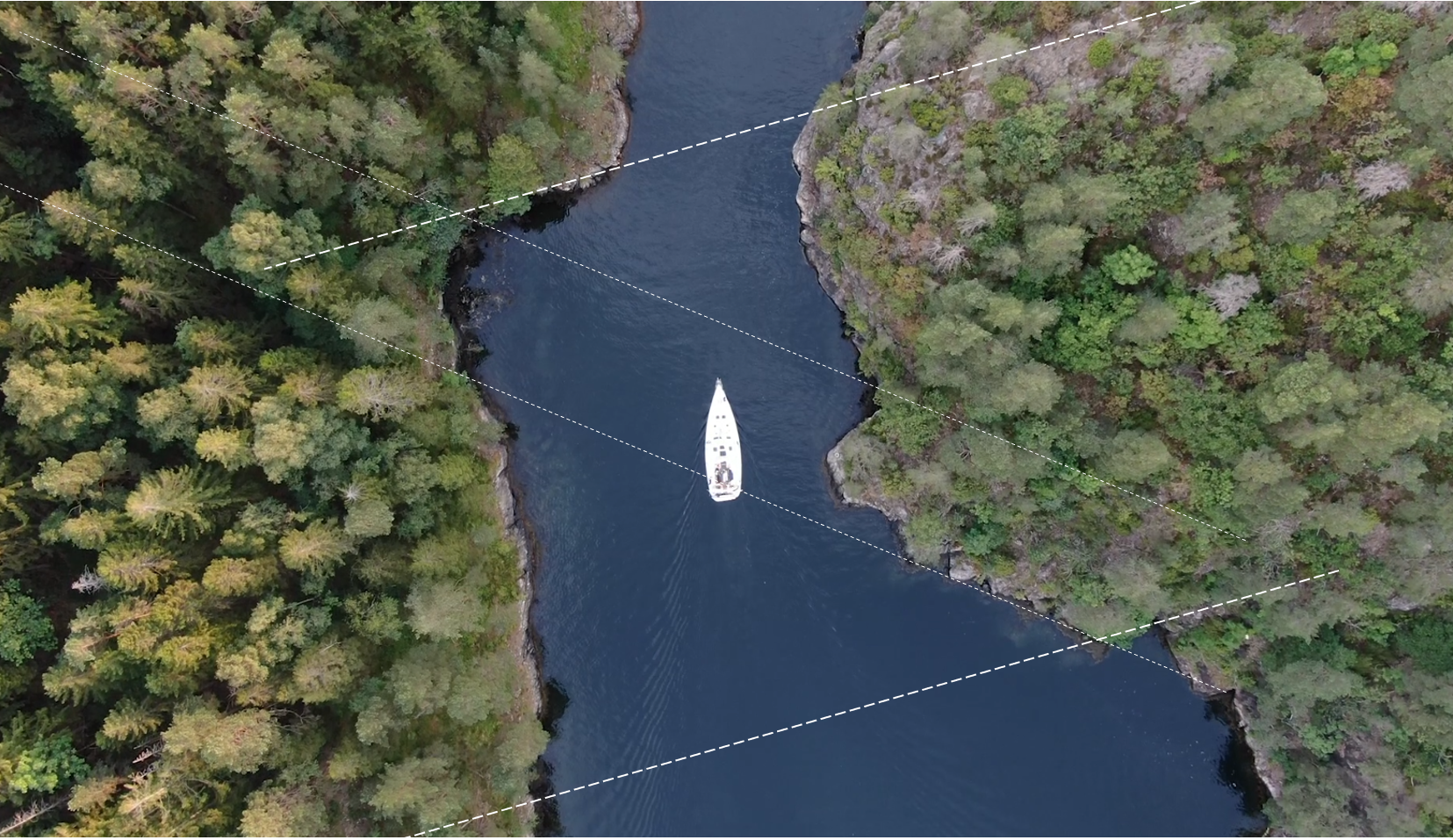
Sailing in the fault zones
Back in Norway, with our electronic navigation charts to make sure to avoid sailing into them widely distributed rocks, we were also sailing in fault zones that have formed in old mylonitic gneiss. They have been heated deeply underneath the mountain chain, which was once 8 km high, and minerals have moved about in the molden rock forming spectacular patterns.
Coming from the very young sediment deposits at Skagen in Denmark, over the 920 million year old Bohus granites in Sweden we were now sailing in rocks with an age between 1.25 and 1.73 billion years.

The image in the center is of Blindleia, which is a long fault zone that extends southwestward from Lillesand.
When sailing in Denmark and depth to seabed is more than 10 m, you feel that you are out in the deep and endless sea. It is NOT like that in Norway where fault and fracture zones have formed steef cliffs both below and above water. It means that you are on the alert if the depth is shallower than 20 m - because things might be coming at you very fast. Or, really, it doesn’t move and it hurts badly.
The advantage is that you can find nice spots for the nights. That, you can’t in Denmark, except for a very small island called Bornholm. But it is basically in Sweden.
Last, but not least, for a structural geologist it is extremely satisfying to sail in fracture and fault zones. Welcome to my world and what I see: geometries and nature in a very organised structure. Recognise the geometries from Malmön?
You can enjoy the full video below, of us sailing through the fault zone between Valle and Kragerø.
Those of you who have read all the way to the end and are geologists, you recognise all of this.
The rest of you have now a better understanding of the dynamic world that we geologists live in, and how big scale we have to accommodate in terms of time and space in our world, understanding what the Earth looks like underneath our feet and how it was formed.
We use this knowledge to find the minerals for your phone and your renewable energy, the asphalt for your roads, the gas for your cooking, the diesel for your car and we also try to make sure that people don’t build nuclear power plants on top of major earth quake zones, when we are asked and they decide to listen.
I hope you all have had a GREAT summer and have charged up your own batteries for what is coming our way for the next few months. I, for one, have prioritised this, because I believe it is going to be quite eventful.
// Sidsel